- Rajasthan
- Kerala
- Maharastra
- Tamilnadu

 City : Jhansi
Location : North India
Language : Hindi
Know About Jhansi
Jhansi pronunciation is a city of Uttar Pradesh state of northern India. Jhansi is a major road and rail junction, and is the administrative seat of Jhansi District and Jhansi Division. The original walled city grew up around its stone fort, which crowns a neighboring rock.
The National Highway Development Project, initiated by the government of Atal Behari Vajpayee, has sparked Jhansi's development. The North-South Corridor connecting Kashmir to Kanyakumari passes through Jhansi. The East-West corridor also goes through this city, so there has been a sudden rush to infrastructure and real estate development in the city. A greenfield airport is also on the anvil.
The National Highway Development Project, initiated by the government of Atal Behari Vajpayee, has sparked Jhansi's development. The North-South Corridor connecting Kashmir to Kanyakumari passes through Jhansi. The East-West corridor also goes through this city, so there has been a sudden rush to infrastructure and real estate development in the city. A greenfield airport is also on the anvil.
History
In the 9th century, the region of Jhansi came under the rule of the Rajput Chandela dynasty of Khajuraho. The artificial reservoirs and architectural remains probably date from this era. The Chandelas were succeeded by their servants the Khangars, who built the nearby fort of Karar. About the fourteenth century the Bundelas poured down upon the plains from the Vindhya Range, and gradually spread themselves over the whole of the Bundelkhand region which now bears their name. The fortress of Jhansi was built by the ruler of Orchha state in 1610. Legend says that when a king of Orchha saw a shadow ('jhain' in bundelkhand) on a distant mound, he is said to have called it jhain-si (kind of shadow). Jhansi got its name from this utterance.
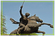
The Revolt of 1857 accordingly found Jhansi ripe for rebellion. In June a few men of the 12th native infantry seized the fort containing the treasure and magazine, and massacred the European officers of the garrison. Rani Lakshmi Bai put herself at the head of the rebels and died bravely in battle in Gwalior. It was not until November, 1858 that Jhansi was brought under British control. It had been given to the Maharaja of Gwalior, but came under British rule in 1886 as the result of a territorial swap. Jhansi was added to the United Provinces, which became the state of Uttar Pradesh after India's Independence in 1947.
The Revolt of 1857 accordingly found Jhansi ripe for rebellion. In June a few men of the 12th native infantry seized the fort containing the treasure and magazine, and massacred the European officers of the garrison. Rani Lakshmi Bai put herself at the head of the rebels and died bravely in battle in Gwalior. It was not until November, 1858 that Jhansi was brought under British control. It had been given to the Maharaja of Gwalior, but came under British rule in 1886 as the result of a territorial swap. Jhansi was added to the United Provinces, which became the state of Uttar Pradesh after India's Independence in 1947.
Geography & Climate
Jhansi is located at 25.4333 N 78.5833 E. It has an average elevation of 284 metres (935 feet).[1] Jhansi is located in the plateau of central India which is mainly rocky area with so much minerals underneath. The city has a natural slope in the north as it lies on the south western border of the vast Tarai plains of Uttar Pradesh. The elevation rises on the south. The land is suitable for citrus species fruits. Crops include wheat, pulses, peas, oilseeds. The region relies heavily on Monsoon rains for irrigation purposes. Under an ambitious canal project(Rajghat canal), the government is constructing a network of canals for irrigation in Jhansi and Lalitpur and some area of Madhya Pradesh.
Being on a rocky plateau, Jhansi experiences extreme temperatures. Little bit of Winter starts in October when the monsoon is over(now a days there is not so much raining in this part because of the global warming) and peaks in mid-December. The mercury moves within the ranges of 4 degrees (minimum, in the mid nights) and 21 degrees (maximum, during the day) on the Celsius scale.
End of the February brings the Spring season here which marks the end of winter. Summer begins in April and summer temperatures are between 34 degrees and 47 degrees Celsius during the day. Summer nights are little cooler after midnight. The rainy season starts in the third week of June( now a days there is a trend that the signs of monsoon are seen in mid may), with Monsoon rains washing central India.
Excursions
Sukma-Dukma Dam: An old, long and very beautiful dam over the Betwa River, approximately 45 km from Jhansi, near Babina town. Very scenic in the post-monsoon (winter) season.
MataTila Dam: Approximately 55 km South of the Jhansi city, it's a very beautiful picnic spot. The dam is built on the river Betwa. There is a botanical garden near the dam site.
Deogarh: 123 km from Jhansi, near Lalitpur town. Situated on the Betwa River, it possesses remains of a fine Gupta period Vishnu temple and several old and beautiful Jain temples.
Orchha: 18 km from Jhansi on Jhansi-Khajuraho road, a small medieval city. It's famous for Lord Ram temple.
Khajuraho: 178 km from Jhansi. Deluxe buses ply from Jhansi railway station to Khajuraho during morning hours. Taxis are also available. One can visit Panna National Park which is 32 km from Khajuraho, and there are some waterfalls nearby.
Datia: 28 km from Jhansi on Jhansi-Gwalior-Agra-Delhi road. It's famous for the Shri Peetambra Devi temple and for a seven-storied palace built by Raja Bir Singh Ju Deo.
Shivpuri: 101 km from Jhansi. It was the summer capital of the Scindia rulers of Gwalior. It's famous for its marble chhatris (cenotaphs) built by the Scindias. There is also a big and beautiful lake with crocodiles in the beautiful Madhav National Park area where one can spot a great variety of wildlife.